Twinning! Spatial Services has created a Digital Twin of NSW
03 March 2020
Working with Data61, DFSI's Spatial Services created a digital real-world model of our cities and communities.
As NSW builds momentum for development throughout the state, DFSI’s Spatial Services and CSIRO’s Data61 have developed an interactive platform to capture and display real-time 3D and 4D spatial data in order to model the urban environment. This upgrade from traditionally held 2D spatial data is the NSW ‘Digital Twin’. The State Infrastructure Strategy 2018 recommended an upgrade to NSW’s spatial data from 2D to real-time 3D and 4D, the launch of this platform is the first step in making this recommendation a reality.
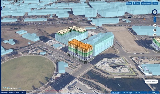
Image: 4D Model showing the internal structure of a building in Penrith as at December 2018.
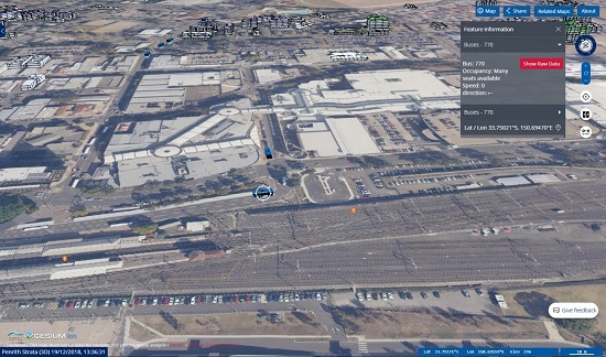
Image: Real-time transport data showing the location, speed and whether seats are available on the 770 bus
Digital Twin NSW is creating a digital real-world model of our cities and communities that will facilitate better planning, design and modelling for NSW’s future needs. Phase one of the Digital Twin included digital visualisations of the local government areas that comprise the Western Sydney City Deal and Greater Parramatta to the Olympic Peninsula. Already the project has demonstrated the ability to upgrade NSW’s Spatial Data to 3D/4D and included the integration of live transport feeds as well as infrastructure building models.
Collaboration with Data61
The Digital Twin was developed with the CSIRO’s Data61 digital research network under the NSW whole-of-government agreement with Data61 and was built on the open source TerriaJS platform.
Wayne Patterson, Director of Spatial Operations, said a great working relationship with Data61, the sharing of expertise and the whole-of-government agreement resulted in a successful Digital Twin proof of concept being delivered in a short timeframe.
What’s next for the Digital Twin?
Continuing into 2019, further engagement with local, state and federal government agencies and industry bodies will see further development and refinement of the platform. The Digital Twin will provide ongoing opportunities for users to have access to aggregated spatially enabled information.
This technology has benefits at national, state and local government levels; from disaster management through to bus schedules. Users of this platform will realise benefits from this state of the art advancement. DFSI and Spatial Services are on track to deliver this project which will revolutionise planning, decision-making, services and security for NSW.
--ENDS--
Source: NSW Government - www.digital.nsw.gov.au
Contact: N/A
External Links:
State Infrastructure Strategy 2018, https://www.nsw.gov.au/improving-nsw/projects-and-initiatives/nsw-state-infrastructure-strategy/
Western Sydney City Deal, https://www.nsw.gov.au/improving-nsw/projects-and-initiatives/western-sydney-city-deal/
Greater Parramatta to the Olympic Peninsula, https://www.greater.sydney/project/gpop
CSIRO’s Data61, https://www.digital.nsw.gov.au/article/accessing-data-experts
TerriaJS, https://terria.io/
Recent news by: NSW Government